![](/images/other/stat-length.png)
![Randonnée V.T.T. Le Pègue - Le sommet de la Lance - Photo](https://media.geolcdn.com/t/1900/400/ext.pjpeg?maxdim=2&url=https%3A%2F%2Fservices.sitytrail.com%2FGeolivesWS%2FDownloadMedia.ashx%3FTrailID%3D101834%26Media%3D2114_5.jpg)
Le sommet de la Lance
tracegps
Utilisateur
![Longueur](/images/other/stat-length.png)
![Altitude max](https://static1.geolcdn.com/siteimages/upload/files/1508320355ic_sort_altitude_max_24dp.png)
![Dénivelé positif](https://static1.geolcdn.com/siteimages/upload/files/1508320355ic_sort_den_pos_24dp.png)
![Km-Effort](/images/other/stat-length.png)
![Altitude min](https://static1.geolcdn.com/siteimages/upload/files/1508320355ic_sort_altitude_min_24dp.png)
![Dénivelé négatif](https://static1.geolcdn.com/siteimages/upload/files/1508320355ic_sort_den_neg_24dp.png)
![Boucle](https://static1.geolcdn.com/siteimages/upload/files/16400158638029165_repeat_loop_refresh_sync_direction_icon.png)
![V.T.T.](https://static1.geolcdn.com/sitytour/trail-icons/202.png)
4h00
Difficulté : Très difficile
![Scannez ce code QR pour ouvrir la randonnée dans l'application SityTrail](https://capi.geolives.com/qq0zvz2zws4bq2lad0pu/sitytour/trails/101834/qr.png?size=200)
Application GPS de randonnée GRATUITE
À propos
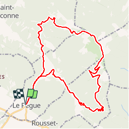
Randonnée V.T.T. de 23 km à découvrir à Auvergne-Rhône-Alpes, Drôme, Le Pègue. Cette randonnée est proposée par tracegps.
Description
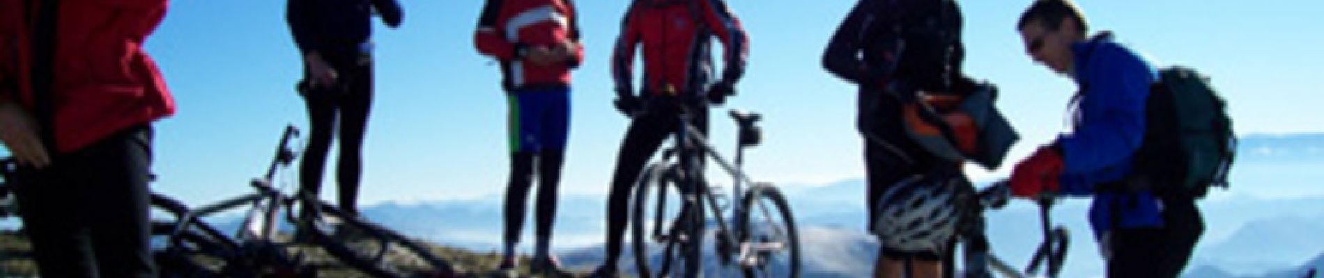
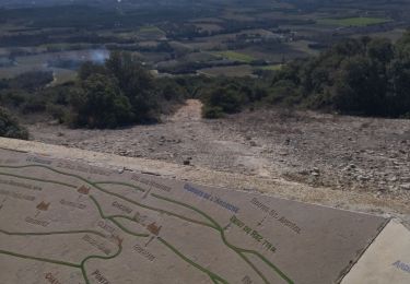
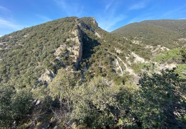
C’est parti pour 13 Km ascension non stop, pente assez régulière sur une piste qui serpente sur la face sud de la Lance. Au fil des kilomètres avec la montée en altitude la vue sur la plaine de Valréas devient de plus en plus vaste. Le sommet est proche et ceux qui aiment les défis seront servis, essayez de sortir la dernière rampe sur le vélo, ce n’est pas gagné !!! Mais rassurez vous, même si vous finissez à pied la récompense est là !!! Un panorama grandiose et une descente inoubliable. Bonne rando à tous !! Auberge de Trente Pas 04.75.27.71.39 ou 0033.4.75.27.71.39 Alain et Véronique Legendre 26110 St Ferréol Trente Pas
Localisation
Commentaires
Randonnées à proximité
![Randonnée Marche Rousset-les-Vignes - Rousset- La Lance - Photo](https://media.geolcdn.com/t/375/260/84d3931f-2eee-4f55-959d-db8a6d419ca0.jpg&format=jpg&maxdim=2)
![Marche Marche](https://static1.geolcdn.com/sitytour/trail-icons/101.png)
Marche
![](/images/other/stat-length.png)
![](https://static1.geolcdn.com/siteimages/upload/files/16400158638029165_repeat_loop_refresh_sync_direction_icon.png)
![Randonnée Marche Rousset-les-Vignes - 26 Rousset les vignes - Photo](https://media.geolcdn.com/t/375/260/ef2bc63b-d52c-4891-aa41-763031d43809.jpg&format=jpg&maxdim=2)
![Marche Marche](https://static1.geolcdn.com/sitytour/trail-icons/101.png)
Marche
![](/images/other/stat-length.png)
![](https://static1.geolcdn.com/siteimages/upload/files/16400158638029165_repeat_loop_refresh_sync_direction_icon.png)
![Randonnée Marche Saint-Pantaléon-les-Vignes - saint panthaleon les vignes - Photo](https://media.geolcdn.com/t/375/260/7a9f88d1-c00e-4ba1-8b0f-b825537fdcb0.jpg&format=jpg&maxdim=2)
![Marche Marche](https://static1.geolcdn.com/sitytour/trail-icons/101.png)
Marche
![](/images/other/stat-length.png)
![](https://static1.geolcdn.com/siteimages/upload/files/16400158638029165_repeat_loop_refresh_sync_direction_icon.png)
![Randonnée Marche Roche-Saint-Secret-Béconne - Roche-Saint-Secret-Beconne : Serre des Vignes. 13km. - Photo](https://media.geolcdn.com/t/375/260/a8478607-a359-49d8-b1f3-5bc502d84c85.jpg&format=jpg&maxdim=2)
![Marche Marche](https://static1.geolcdn.com/sitytour/trail-icons/101.png)
Marche
![](/images/other/stat-length.png)
![](https://static1.geolcdn.com/siteimages/upload/files/16400158638029165_repeat_loop_refresh_sync_direction_icon.png)
![Randonnée Marche Montbrison-sur-Lez - 26 pas montbrison sur lez zel - Photo](https://media.geolcdn.com/t/375/260/bacfc4b3-af23-46bb-8d7d-71696c1ea095.jpg&format=jpg&maxdim=2)
![Marche Marche](https://static1.geolcdn.com/sitytour/trail-icons/101.png)
Marche
![](/images/other/stat-length.png)
![](https://static1.geolcdn.com/siteimages/upload/files/16400158638029165_repeat_loop_refresh_sync_direction_icon.png)
![Randonnée Marche Rousset-les-Vignes - Rousset les vignes sous La Chapelle - Photo](https://media.geolcdn.com/t/375/260/b76d0e6c-736e-44c5-b779-1ce4c6c7950a.jpg&format=jpg&maxdim=2)
![Marche Marche](https://static1.geolcdn.com/sitytour/trail-icons/101.png)
Marche
![](/images/other/stat-length.png)
![](https://static1.geolcdn.com/siteimages/upload/files/16400158638029165_repeat_loop_refresh_sync_direction_icon.png)
![Randonnée Marche Saint-Pantaléon-les-Vignes - Saint Pantaleon crevasses. - Photo](https://media.geolcdn.com/t/375/260/45ec6a80-1cce-4239-97f4-da896d149d69.jpg&format=jpg&maxdim=2)
![Marche Marche](https://static1.geolcdn.com/sitytour/trail-icons/101.png)
Marche
![](/images/other/stat-length.png)
![](https://static1.geolcdn.com/siteimages/upload/files/16400158638029165_repeat_loop_refresh_sync_direction_icon.png)
![Randonnée Marche Venterol - Col de la Sausse par la Combe de Sauve - Photo](https://media.geolcdn.com/t/375/260/ext.jpg?maxdim=2&url=https%3A%2F%2Fstatic1.geolcdn.com%2Fsiteimages%2Fupload%2Ffiles%2F1553511878bg_sport_marche.png)
![Marche Marche](https://static1.geolcdn.com/sitytour/trail-icons/101.png)
Marche
![](/images/other/stat-length.png)
![](https://static1.geolcdn.com/siteimages/upload/files/16400158638029165_repeat_loop_refresh_sync_direction_icon.png)
![Randonnée V.T.T. Venterol - Dir . Valreas - Photo](https://media.geolcdn.com/t/375/260/ext.jpg?maxdim=2&url=https%3A%2F%2Fstatic1.geolcdn.com%2Fsiteimages%2Fupload%2Ffiles%2F1524743154velo.jpg)
![V.T.T. V.T.T.](https://static1.geolcdn.com/sitytour/trail-icons/202.png)
V.T.T.
![](/images/other/stat-length.png)
![](https://static1.geolcdn.com/siteimages/upload/files/16400158638029165_repeat_loop_refresh_sync_direction_icon.png)